By Wilson Sheldon
Recently, the Red’s Farm Preserve Park Pride Visioning Steering Committee embarked on an enlightening field trip to the Atlanta History Center (AHC). The purpose of the visit was to research the history of the land now occupied by Red’s Farm Preserve, as well as the broader historical development of Ormewood Park.
The trip was thoughtfully organized by Teri Nye, Director of Park Visioning at Park Pride, along with Nick Voravong, Associate Director, on a beautiful mid-December day. Steering Committee members Whitney Barr and Wilson Sheldon also attended. The committee members were grateful to the knowledgeable librarians and staff at the Atlanta History Center, who had prepared in advance a collection of Sanborn Insurance Maps and other archival materials specific to our neighborhood and surrounding target areas.
Any thorough historical examination of this land must begin with the Muscogee (Creek) Nation and their ancestors, the original and longtime inhabitants of the region. However, for the purposes of the committee’s research at AHC, the investigation began with the Civil War—specifically the Battle of Atlanta in the summer of 1864. While the Battle of Atlanta has been covered extensively in The Porch Press over the years, there are some lesser-known details relating directly to the land where Red’s Farm now sits.
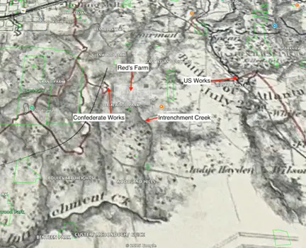
By overlaying a recent Red’s Farm property survey onto an 1864 Battle of Atlanta map—and then layering both over modern Google Maps—the committee observed that Confederate earthworks branching east from the Confederate-controlled rail line (later the Atlanta + West Point Belt Line, and now the Beltline) extended to the western edge of the farm. Union earthworks, meanwhile, were positioned in East Atlanta. This suggests that there was likely significant activity on, around, and across the land during the conflict. Many longtime residents may have heard—or perhaps heard Red himself say—that the trenches on the farm were dug by soldiers, or that General Sherman camped on the property after the battle before heading south along what is now Moreland Avenue.
In Red’s personal archives, the Harrison family located a letter from 2006 in which a historian with the Georgia Civil War Commission analyzed the trenches. The historian concluded that because the primary battle occurred approximately half a mile northeast of the farm, “the earthworks may have been prepared by dismounted Federal cavalry when they were responsible for the left flank before and after the late July raids that culminated at Sunshine Church.”
As the committee’s research progressed into the postwar period, attention turned to Ormewood Park’s gradual transition from a rural landscape to an urban neighborhood. Large landowners—most notably H. L. Woodward, who lived in a substantial home across from what is now Holy Comforter Episcopal Church—began subdividing their family holdings. Along the way, the committee uncovered a curious fact: Woodland Avenue has changed names at least three times. Originally known as Woodward Avenue, it briefly became Woodlawn before settling on its current name, Woodland.
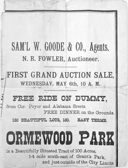
Moving into the early twentieth century, the archives revealed a flood of advertisements placed by real estate developers and auctioneers enticing prospective homeowners. Many promoted a “free ride on the trolley” and a “free dinner” as incentives to explore the brand-new subdivision. After all, the ads proudly noted, it was only two and a half miles to the Kimball House—and just outside the city limits.
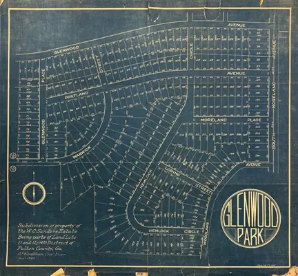
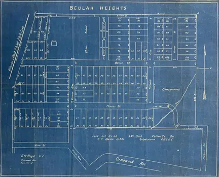
By 1917–1919, Beulah Heights College and Seminary was already well established on Berne Street, where it remains today. At that time, the surrounding neighborhood was also known as Beulah Heights, extending from Berne Street down to Ormewood Avenue and over to the “campground”—the land that would later become Red’s Farm. (Glenwood Park occupied the area north of Berne to Glenwood Avenue, while Brook-Haven lay south of Ormewood Avenue toward Confederate and United Avenues.)
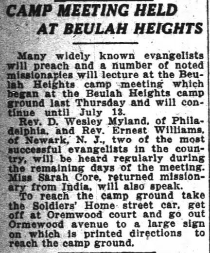
During this period, Beulah Heights regularly hosted camp meetings and religious revivals on the land, often advertising in local newspapers and highlighting well-traveled missionaries and ministers. One such advertisement from 1919 illustrates the importance of the site as a gathering place for the wider community.
The committee also discussed long-held neighborhood knowledge that, before the land became Beulah Heights’ campground, it operated as a dairy farm, with cows receiving drinking water from Intrenchment Creek. Although this detail was not documented in the archival materials reviewed at AHC, it aligns with the area’s rural character during that period and remains part of the site’s remembered history.
One especially compelling map uncovered during the visit documented Intrenchment Creek as it runs through the Red’s Farm property and beneath Ormewood Avenue today. Historic maps show an early bridge crossing the creek—a modest but essential piece of infrastructure that connected farms, campgrounds and emerging neighborhoods. While easily overlooked today, the bridge serves as a reminder that natural features—streams, lowlands and wooded corridors—quietly shaped how the neighborhood grew and how people moved through it.
Red’s Farm Preserve occupies a rare position in Ormewood Park: a place where layers of use overlap rather than erase one another. From Indigenous land to wartime landscape, from revival campground to working farm and now public green space, the land has consistently served as a gathering place. The committee’s work at the Atlanta History Center underscored that visioning for the future of Red’s Farm is not an act of reinvention, but of stewardship—continuing a long tradition of shared use while thoughtfully adapting it for the next generation.
Those who attended the first public Red’s Farm visioning meeting in December may recall Teri Nye’s detailed timeline displayed at the back of the room. That timeline incorporated much of the committee’s research from the Atlanta History Center. Park Pride also encouraged attendees to contribute their own entries, reinforcing the idea that Red’s Farm’s history continues to be written. One such addition marked 2024 as the founding of UFO (Urban Farm in Ormewood), the “Friends of” group that now works with the City of Atlanta to maintain and help guide Red’s Farm Preserve.
To learn more about the Red’s Farm Preserve Park Pride Visioning Plan, please visit ufoatlanta.org and select “Visioning Plan.” The committee looks forward to welcoming the public again for Public Meeting 3 (of three), entitled “Vision Plan,” on Wednesday, April 22, 2026, at 6:30pm at Ormewood Church.